Cuando hablamos de monumentos nos referimos por lo general a edificios históricos, obras de arte y construcciones en general con un legado histórico nacional, regional o internacional relacionado con la cultura en general.
En este caso me voy a apartar de esta corriente ideológica y les voy a hablar de un monumento (en realidad hay varios en Argentina) que identifica un legado de nuestros antepasados, una auténtica tradición argentina que reconoce sus orígenes en la cultura precolombina y que se encuentra ubicado en la ciudad de Santa Rosa, capital de la provincia de La Pampa en Argentina.
El mate es un emblema en lo que una vez se llamaba el virreinato del Río de La Plata, especialmente Argentina, Uruguay y Paraguay, de donde es nativa la yerba mate (Ilex paraguariensis) llamada yerba de los jesuitas o yerba del Paraguay, en guaraní se llama ka'a. A partir del año 2013 esta bebida popular ha sido declarada, oficialmente, “infusión nacional” promoviendo su uso y consumo en todos los sectores de la sociedad.
En realidad los indios guaraníes del Paraguay la usaban como planta medicinal llamándola “caa guazú” que traducida del guaraní al español significaría algo así como la “espléndida yerba”, ya que tiene propiedades estimulantes (a través de la sustancia llamada mateina), servía para curar las heridas, triturada y en forma de polvo, o para evitar los espasmos o sedar los nervios.
El mate fue adoptado rápidamente como bebida popular (en realidad es una infusión) durante el siglo XX en otros países limítrofes, Paraguay, Bolivia y parte de Chile y Brasil.
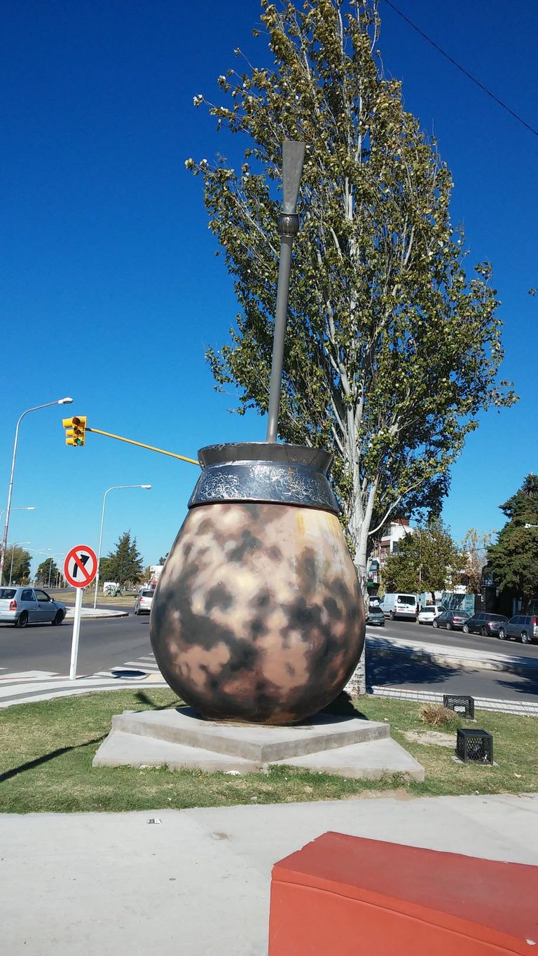
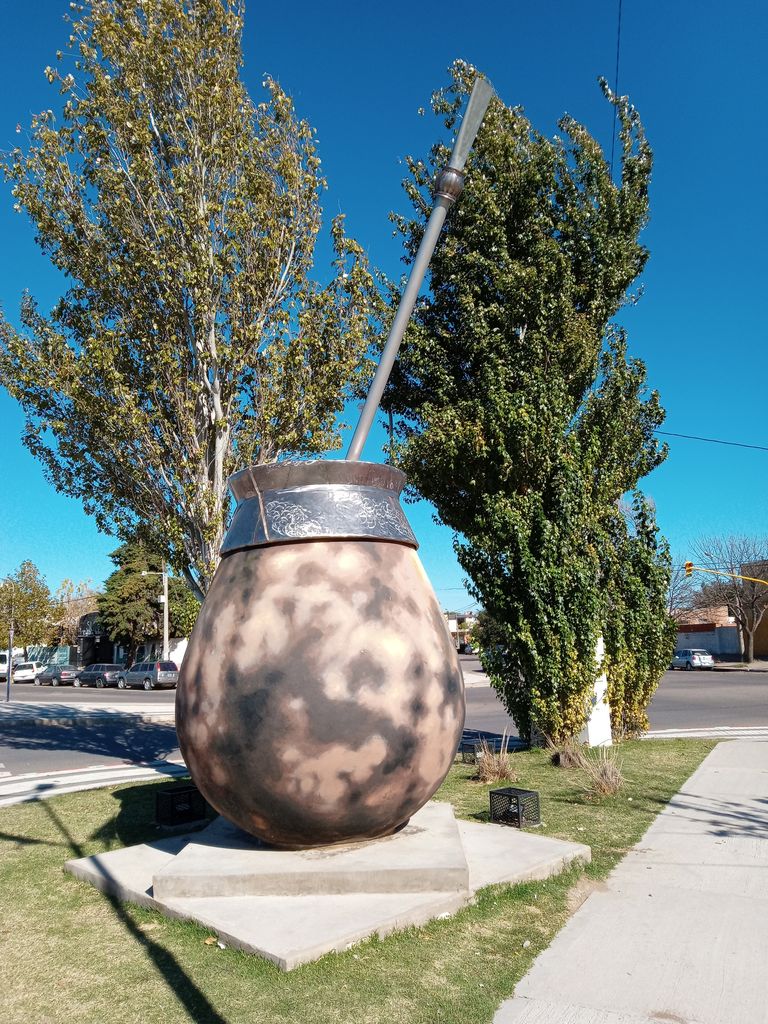
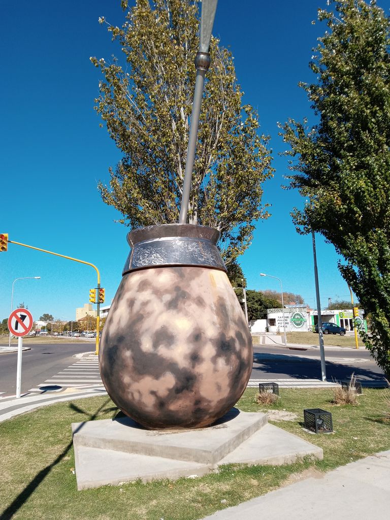
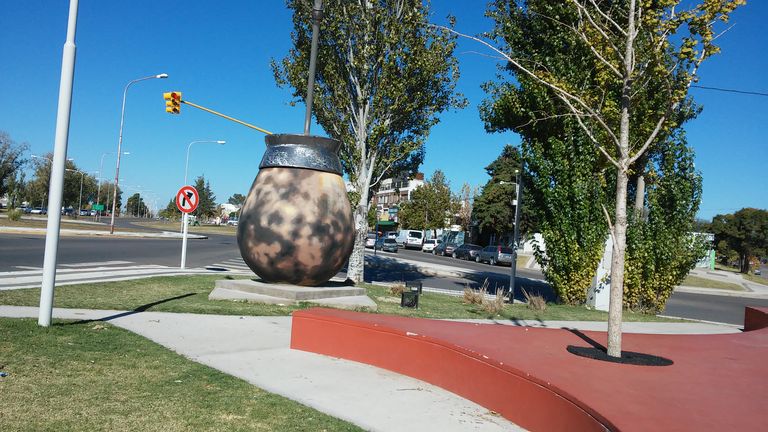
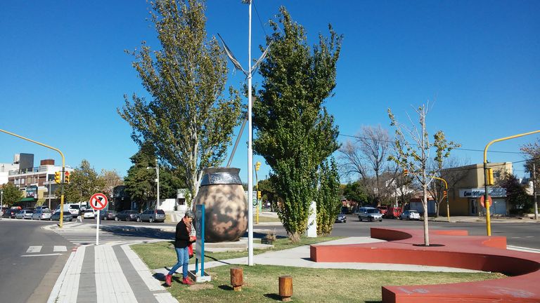
Monumento al mate.
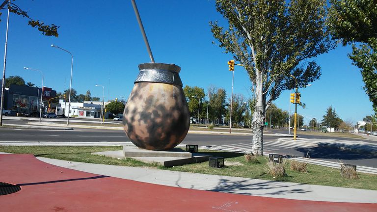
El monumento, hecho en hormigón, fue construido en el año 1971, en plena transición de los gobiernos militares que gobernaron Argentina por décadas a los gobiernos democráticos que luego de un breve impasse fueron de nuevo interrumpidos por un nuevo golpe militar, durante el mandato de Benjamín Santos Trapaglia, que en ese momento era el gobernador de la provincia de La Pampa, el intendente municipal de la ciudad de Santa Rosa (donde se encuentra el Monumento al Mate) Eduardo Feliz Molteni.
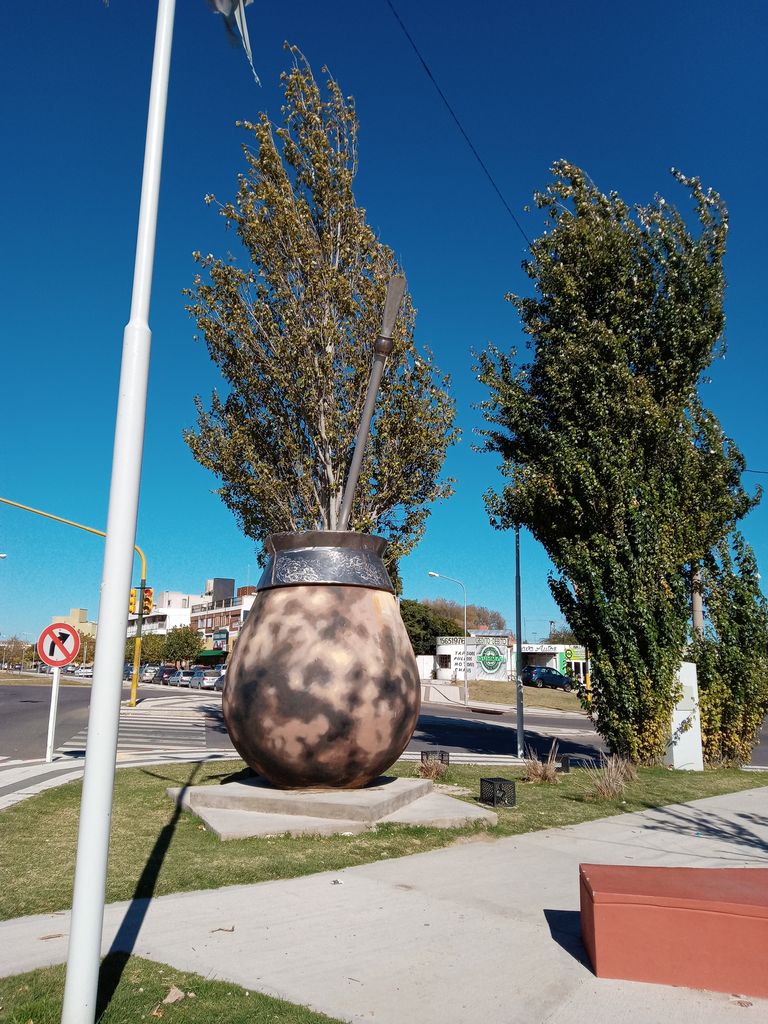
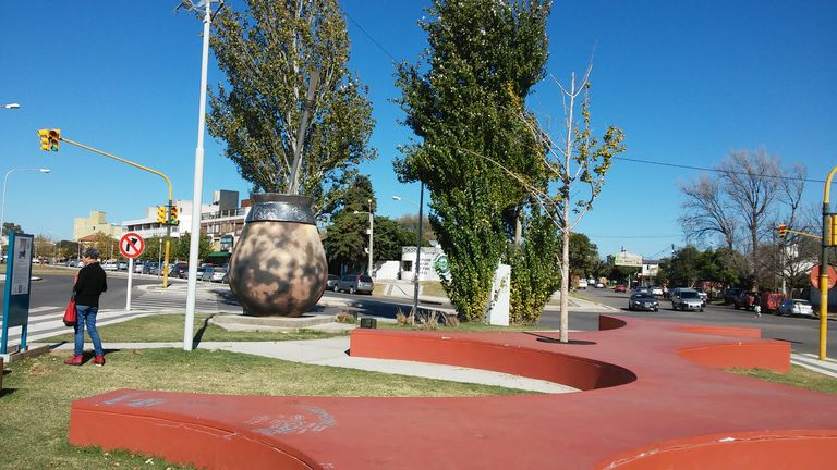
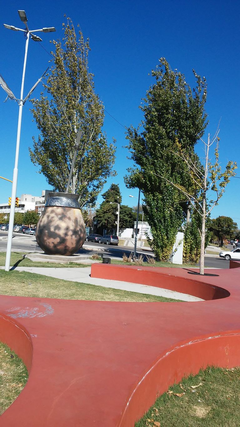
Antes del 2000 la popularidad del monumento fue tal (en ese entonces esa parte de la ciudad todavía estaba escasamente poblado y el monumento podía avistarse desde lejos) que el municipio local decidió construir una plazoleta llamada precisamente Plazoleta del Mate, colocando un monolito con placa alusiva
El Monumento al Mate es considerado una de esas esculturas o monumentos completamente únicos y poco conocidos que se encuentran distribuidos en todo el mundo. En el año 2021 ha sido totalmente restaurado.
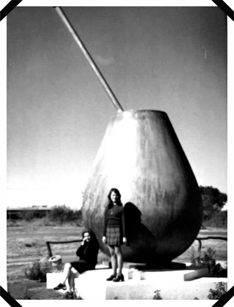
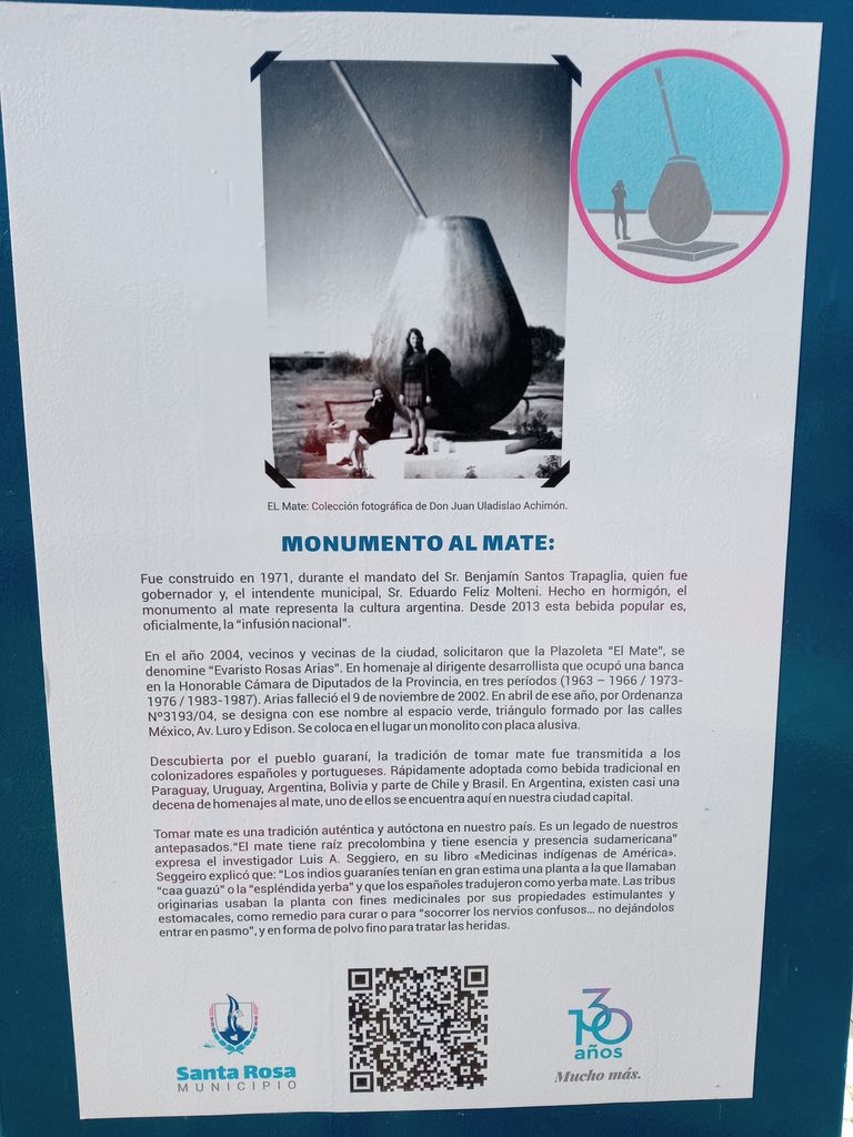
La imagen de archivo -perteneciente a la colección privada El Mate de Juan Uladislao Achimón- publicada en la sección cultura de la Municipalidad de Santa Rosa muestra como era el monumento pocos días después de su inauguración en el año 1971, y sobre todo cuan escasamente poblada estaba la capital pampeana en década del setenta. En ese momento Santa Rosa no superaba los 60-70.000 habitantes. Medio siglo más cuenta, en la actualidad, ha superado los 200.000 habitantes.
En el año 2004 por iniciativa de vecinos del lugar se intentó cambiar el nombre del monumento sugiriendo el nombre del dirigente desarrollista Evaristo Rosas Arias. Sin embargo, la población rechazó tal iniciativa aceptando solamente que ese nombre fuera dado a la Plazoleta en sí misma y no al monumento que sigue teniendo su nombre tradicional.

When we talk about monuments we usually refer to historical buildings, works of art and constructions in general with a national, regional or international historical legacy related to culture in general.
In this case I am going to depart from this ideological current and I am going to talk about a monument (actually there are several in Argentina) that identifies a legacy of our ancestors, an authentic Argentine tradition that recognizes its origins in the pre-Columbian culture and that is located in the city of Santa Rosa, capital of the province of La Pampa in Argentina.
Mate is an emblem in what was once called the viceroyalty of the Río de La Plata, especially Argentina, Uruguay and Paraguay, where yerba mate (Ilex paraguariensis) is native, called yerba de los jesuitas or yerba del Paraguay, in Guarani it is called ka'a. Since 2013 this popular drink has been officially declared "national infusion", promoting its use and consumption in all sectors of society.
In fact, the Guarani Indians of Paraguay used it as a medicinal plant, calling it "caa guazú", which translated from Guarani into Spanish would mean something like "splendid yerba", since it has stimulating properties (through the substance called mateina), it was used to heal wounds, crushed and in powder form, or to prevent spasms or to sedate the nerves.
Mate was quickly adopted as a popular drink (it is actually an infusion) during the 20th century in other neighboring countries, Paraguay, Bolivia and part of Chile and Brazil.
Monument to mate.
The monument, made of concrete, was built in 1971, in the middle of the transition from the military governments that ruled Argentina for decades to the democratic governments that after a brief impasse were again interrupted by a new military coup, during the mandate of Benjamín Santos Trapaglia, who at that time was the governor of the province of La Pampa, the municipal mayor of the city of Santa Rosa (where the Mate Monument is located) Eduardo Feliz Molteni.
Before 2000 the popularity of the monument was such (at that time that part of the city was still sparsely populated and the monument could be seen from far away) that the local municipality decided to build a small square called Plazoleta del Mate, placing a monolith with an allusive plaque.
The Monumento al Mate is considered one of those completely unique and little known sculptures or monuments that are distributed all over the world. In the year 2021 it has been completely restored.
The archive image -belonging to the private collection El Mate de Juan Uladislao Achimón- published in the culture section of the Municipality of Santa Rosa shows what the monument looked like a few days after its inauguration in 1971, and above all how sparsely populated the capital of the Pampa was in the seventies. At that time Santa Rosa had no more than 60-70,000 inhabitants. Half a century later, today, it has more than 200,000 inhabitants.
In 2004, at the initiative of local residents, an attempt was made to change the name of the monument by suggesting the name of the development leader Evaristo Rosas Arias. However, the population rejected this initiative, accepting only that this name be given to the Plazoleta itself and not to the monument, which continues to have its traditional name.
Cuando hablamos de monumentos nos referimos por lo general a edificios históricos, obras de arte y construcciones en general con un legado histórico nacional, regional o internacional relacionado con la cultura en general.
En este caso me voy a apartar de esta corriente ideológica y les voy a hablar de un monumento (en realidad hay varios en Argentina) que identifica un legado de nuestros antepasados, una auténtica tradición argentina que reconoce sus orígenes en la cultura precolombina y que se encuentra ubicado en la ciudad de Santa Rosa, capital de la provincia de La Pampa en Argentina.
El mate es un emblema en lo que una vez se llamaba el virreinato del Río de La Plata, especialmente Argentina, Uruguay y Paraguay, de donde es nativa la yerba mate (Ilex paraguariensis) llamada yerba de los jesuitas o yerba del Paraguay, en guaraní se llama ka'a. A partir del año 2013 esta bebida popular ha sido declarada, oficialmente, “infusión nacional” promoviendo su uso y consumo en todos los sectores de la sociedad.
En realidad los indios guaraníes del Paraguay la usaban como planta medicinal llamándola “caa guazú” que traducida del guaraní al español significaría algo así como la “espléndida yerba”, ya que tiene propiedades estimulantes (a través de la sustancia llamada mateina), servía para curar las heridas, triturada y en forma de polvo, o para evitar los espasmos o sedar los nervios.
El mate fue adoptado rápidamente como bebida popular (en realidad es una infusión) durante el siglo XX en otros países limítrofes, Paraguay, Bolivia y parte de Chile y Brasil.
Monumento al mate.
El monumento, hecho en hormigón, fue construido en el año 1971, en plena transición de los gobiernos militares que gobernaron Argentina por décadas a los gobiernos democráticos que luego de un breve impasse fueron de nuevo interrumpidos por un nuevo golpe militar, durante el mandato de Benjamín Santos Trapaglia, que en ese momento era el gobernador de la provincia de La Pampa, el intendente municipal de la ciudad de Santa Rosa (donde se encuentra el Monumento al Mate) Eduardo Feliz Molteni.
Antes del 2000 la popularidad del monumento fue tal (en ese entonces esa parte de la ciudad todavía estaba escasamente poblado y el monumento podía avistarse desde lejos) que el municipio local decidió construir una plazoleta llamada precisamente Plazoleta del Mate, colocando un monolito con placa alusiva
El Monumento al Mate es considerado una de esas esculturas o monumentos completamente únicos y poco conocidos que se encuentran distribuidos en todo el mundo. En el año 2021 ha sido totalmente restaurado.
La imagen de archivo -perteneciente a la colección privada El Mate de Juan Uladislao Achimón- publicada en la sección cultura de la Municipalidad de Santa Rosa muestra como era el monumento pocos días después de su inauguración en el año 1971, y sobre todo cuan escasamente poblada estaba la capital pampeana en década del setenta. En ese momento Santa Rosa no superaba los 60-70.000 habitantes. Medio siglo más cuenta, en la actualidad, ha superado los 200.000 habitantes.
En el año 2004 por iniciativa de vecinos del lugar se intentó cambiar el nombre del monumento sugiriendo el nombre del dirigente desarrollista Evaristo Rosas Arias. Sin embargo, la población rechazó tal iniciativa aceptando solamente que ese nombre fuera dado a la Plazoleta en sí misma y no al monumento que sigue teniendo su nombre tradicional.
When we talk about monuments we usually refer to historical buildings, works of art and constructions in general with a national, regional or international historical legacy related to culture in general.
In this case I am going to depart from this ideological current and I am going to talk about a monument (actually there are several in Argentina) that identifies a legacy of our ancestors, an authentic Argentine tradition that recognizes its origins in the pre-Columbian culture and that is located in the city of Santa Rosa, capital of the province of La Pampa in Argentina.
Mate is an emblem in what was once called the viceroyalty of the Río de La Plata, especially Argentina, Uruguay and Paraguay, where yerba mate (Ilex paraguariensis) is native, called yerba de los jesuitas or yerba del Paraguay, in Guarani it is called ka'a. Since 2013 this popular drink has been officially declared "national infusion", promoting its use and consumption in all sectors of society.
In fact, the Guarani Indians of Paraguay used it as a medicinal plant, calling it "caa guazú", which translated from Guarani into Spanish would mean something like "splendid yerba", since it has stimulating properties (through the substance called mateina), it was used to heal wounds, crushed and in powder form, or to prevent spasms or to sedate the nerves.
Mate was quickly adopted as a popular drink (it is actually an infusion) during the 20th century in other neighboring countries, Paraguay, Bolivia and part of Chile and Brazil.
Monument to mate.
The monument, made of concrete, was built in 1971, in the middle of the transition from the military governments that ruled Argentina for decades to the democratic governments that after a brief impasse were again interrupted by a new military coup, during the mandate of Benjamín Santos Trapaglia, who at that time was the governor of the province of La Pampa, the municipal mayor of the city of Santa Rosa (where the Mate Monument is located) Eduardo Feliz Molteni.
Before 2000 the popularity of the monument was such (at that time that part of the city was still sparsely populated and the monument could be seen from far away) that the local municipality decided to build a small square called Plazoleta del Mate, placing a monolith with an allusive plaque.
The Monumento al Mate is considered one of those completely unique and little known sculptures or monuments that are distributed all over the world. In the year 2021 it has been completely restored.
The archive image -belonging to the private collection El Mate de Juan Uladislao Achimón- published in the culture section of the Municipality of Santa Rosa shows what the monument looked like a few days after its inauguration in 1971, and above all how sparsely populated the capital of the Pampa was in the seventies. At that time Santa Rosa had no more than 60-70,000 inhabitants. Half a century later, today, it has more than 200,000 inhabitants.
In 2004, at the initiative of local residents, an attempt was made to change the name of the monument by suggesting the name of the development leader Evaristo Rosas Arias. However, the population rejected this initiative, accepting only that this name be given to the Plazoleta itself and not to the monument, which continues to have its traditional name.